California has one of the most diverse hiking landscapes in the country. From alpine lakes to desert sand to coastal views, you can easily find an epic hike that’s less than 2 hours away from the Los Angeles area. Check out my list of the top 11 best hikes in Southern California and start planning your day trip escape into nature!

SEE ALSO: Backpacking Big Pine Lakes: an Epic California Weekend Adventure
Things You Need for a Day Hike in Southern California
When doing any of my recommended best hikes in Southern California – even though these are just day hikes – you need to make sure you are prepared! In addition to the below, make sure you always bring more water than you think you need, and wear sunscreen.
As an Amazon Associate I earn from qualifying purchases.
- Hiking Boots (these are my favorite!) For some of the easier hikes, sneakers are fine. But for the longer/more difficult ones, it’s best to wear hiking boots to have a good grip on the terrain!
- The COLDEST Water bottle (seriously – it stays colder than Hydroflask!)
- Clif Bar Energy Chews – to give you a boost of energy on longer hikes!
- Nano Puff Jacket – for a chilly early morning hike sesh
- Camelbak to easily carry extra water on the trails
- Leggings with Pockets For all the ladies reading this – I pretty much always wear leggings with pockets on my hikes, mostly because I can keep my phone in my pocket to easily take out on the fly to snap a pic
- Day Pack – It’s always a good idea to pack snacks, extra water, and extra layers in a small backpack!
- Coola Sunscreen – I LOVE this face sunscreen! It’s light on your face, uses organic ingredients and smells great.
Top 11 Best Hikes in Southern California
1. Bridge to Nowhere Hike

- Location: San Gabriel Mountains
- Distance: 10 miles
- Difficulty: Moderate
- Elevation Gain: 1,870 ft
This hike is absolutely beautiful, and is only about 1.5 hours from LA! It’s definitely one of the best hikes in Southern California. Tucked away in the San Gabriel Mountains, the Bridge to Nowhere is an actual bridge that was constructed in the 1930’s. However, the road connecting the bridge was washed away in a flood. Now what remains is a super scenic 5-mile hiking trail following the San Gabriel river leading up to this bridge. You cross the river about 6 times during this hike, so make sure you wear shoes that you’re fine with getting wet. I recommend these Keen water hiking sandals. There’s a parking lot at the trail head so it’s pretty easy to find – just put “East Fork Day Use Parking Trailhead” into your maps!
Something else that makes this hike unique – you can bungee jump off the Bridge to Nowhere through Bungee America! It’s actually the only place you can bungee jump in Southern California. The Bungee America guides will meet you at the trailhead and lead you on the hike up to the bridge. This was great, because sometimes the trail was a little hard to follow in my opinion. This was my first time bungee jumping, and it was an absolute blast!
If you don’t plan on bungee jumping, the hike itself is still totally worth doing. And you can also be entertained watching others jump off once you get to the bridge! The Hiking Guy has some really detailed step-by-step directions in case you want to read up before you hit the trail.


2. Portugese Bend Reserve

- Location: Palos Verdes
- Distance: 3 miles
- Difficulty: Easy
- Elevation Gain: 855 ft
Palos Verdes is full of chill hikes with great views, and Portugese Bend is one of the best! This 3-mile loop offers beautiful views of the Pacific Ocean and Catalina off in the distance. You can simply put “Portugese Bend Reserve” into your Google Maps and it will take you to the park entrance. Park on the free street parking on Crenshaw Blvd (the road leading up to the park) and walk through/over the gate onto Burma Road Trail to begin the hike.


The main road of the hike is wide and can get a bit crowded on the weekend, but there are little off-shoots of the trail that run parallel to the main road that have more of a nature feel. Once you make your way to the coastline, sit down and enjoy the view! Pro tip – bring a little picnic and/or beers to enjoy at this spot.
3. Big Horn Mine

- Location: Angeles National Forest
- Distance: 4 miles
- Difficulty: Easy
- Elevation Gain: 840 ft
Big Horn Mine is one of the best hikes in Southern California because it is so unique and historical. This hike is a great introduction into the Angeles National Forest – and is good for any skill level! The hike is easy but beautiful, and leads to an old abandoned mine at the end. Put “Vincent Gap” into your Google Maps and park here. It’s about 2 hours from L.A.
Gold was discovered at Big Horn Mine back in 1891 by Charles Vincent, as he was hunting Big Horn Sheep. The mine closed down in 1985, and has since been abandoned (and now makes for a great photo-op!). When I went, the weather was beautiful the whole hike until we got to the mine and the fog rolled in – ha! I still want to go back sometime and see the view from the mine on a clear day.
If you bring a headlamp, you can also explore these little tunnels in the mountain that were used back in the day for gold mining.


Pro tip – stop in the cute town of Wrightwood on the way back to L.A for a drink and a bite to eat!
4. Wisdom Tree – Cahuenga Peak – Mount Lee
- Location: Los Angeles
- Distance: 3 miles
- Difficulty: Moderate
- Elevation Gain: 872 ft

The Wisdom Tree hike is a quintessential Los Angeles hike. This somewhat rugged trail is located in Griffith Park and is pretty steep the whole climb up, on a loose-dirt trail. Once you reach the top, huffing and puffing, you will see the lone “Wisdom Tree” at the top. This is the only tree that survived the Hollywood fire in 2007.
Enjoy the views of the city from the shade of the tree and relax before continuing on the ridge-line trail to Cahuenga Peak and then further on to Mount Lee. The trail is pretty straightforward, but does require a bit of scrambling over rocks and through some brush. You’ll then reach Mount Lee and will have landed right at the back side of the Hollywood Sign! This is my favorite Hollywood Sign hike, because you can get super close to it and have the unique view from the back. You’ll notice some people at the sign who didn’t just do the somewhat strenuous hike to get there, and instead drove up the paved road. But of course, I think hiking to it is way more fun and rewarding.


Pro tip – go on a weekday to avoid some of the crowds, and reward yourself with some dank food in LA after (I should really write a blog post about that, but there’s just too many amazing places!)
5. Potato Chip Rock
- Location: Lake Poway
- Distance: 7.6 miles
- Difficulty: Moderate/Difficult
- Elevation Gain: 2,106 ft

Potato Chip Rock is one of the most popular Southern California hiking trails, mainly for the great photo-op at the summit with this super thin rock that looks like – you guessed it – a potato chip. It’s about 2 hours south of Los Angeles, and makes for a great adventure day if you wake up early enough!
The hike itself is beautiful, but also challenging. There is hardly any shade (make sure to wear sunscreen and pack more water than you think you’ll need!!) and it feels like this trail has you hiking uphill for most of the time. Park in the Lake Poway parking lot. Note that it’s free on weekdays, but $10 on the weekends. It starts out easy and pleasant, taking you right around scenic Lake Poway.

The trail take you to the summit of Mt Woodson. Around the last mile of the hike, you’ll see lots of opportunities for super scenic lookout points, and interesting rock formations before you reach the actual Potato Chip Rock.
I’ve read that there can be a big crowd at the top waiting in line to get their picture taken on Potato Chip Rock. However, we must have gotten lucky when we went (on a Sunday) because once we reached the top, there was only 2 other people up there! It was foggy for about 30 minutes, but we chilled out, ate a snack, drank a beer, and then the fog burned off and it was beautiful!


Note – there is another, shorter trail to get here that comes up the other side of the mountain that you park on the side of the road for, but the trail is mostly all paved, which really turns me off. I recommend the main trail from Lake Poway as it is full of nature, dirt trails and challenging ascents.
6. Escondido Falls
- Location: Malibu
- Distance: 4 miles
- Difficulty: Easy/Moderate
- Elevation Gain: 400 ft
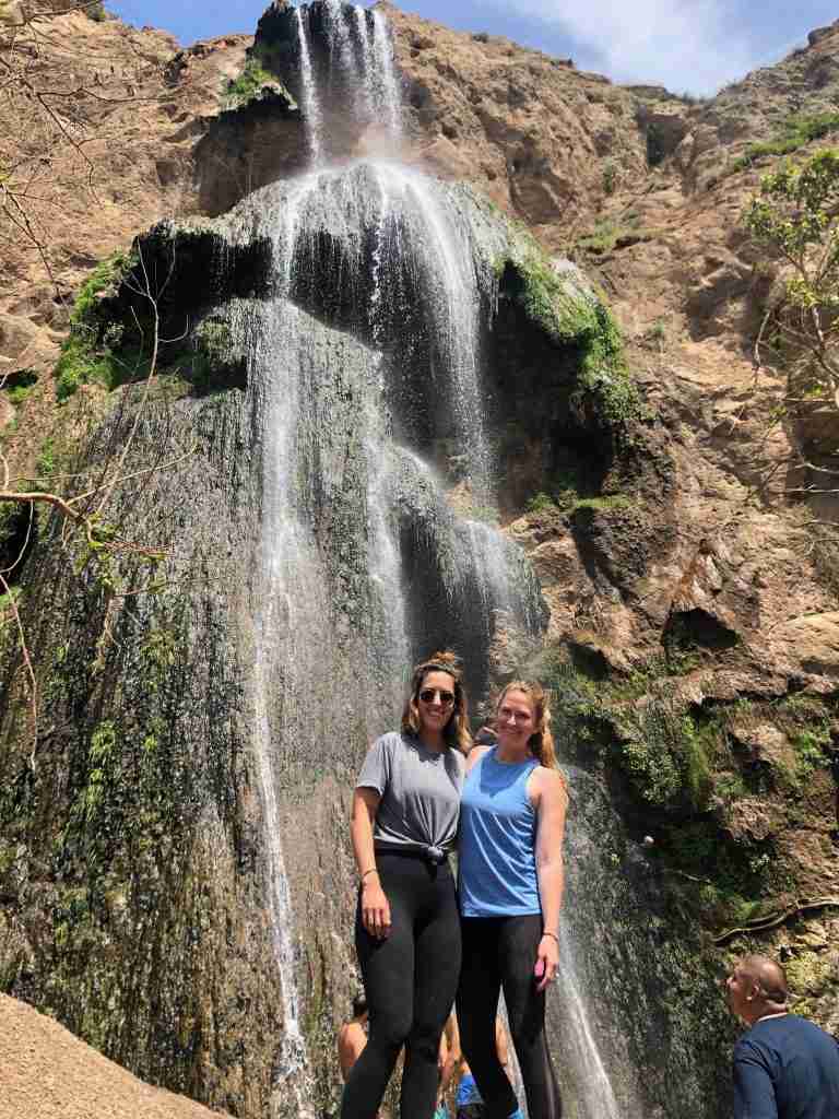
Escondido Falls is one of the best waterfalls in the Los Angeles area, and the hike is really fun! Put “Visitor parking for Escondido Falls” into your Google Maps, which will take you to the parking lot right off the PCH/Winding Road in Malibu. The first mile of the trail is on a paved road, but then it turns into a dirt trail surrounded by wildflowers (in the right season), trees, and a flowing creek. After about a mile, you’ll reach the first waterfall.

The first waterfall is nice, but if you’re feeling adventurous, I definitely recommend making the extra trek up to the Upper Escondido Falls. Take the the steep dirt trail to the right, and start (carefully) making your way up. The trail is on loose dirt so it can be hard to get your footing – try to use roots and rocks to help you up. I ended up crawling with my hands for part of the way. It’s kind of tricky, but at the time I did this hike I had received stitches in my thumb the day prior and also had a dislocated shoulder, and still made it up (haha). So I’m sure you can too! Just do what feels safe within your ability level.
Once you reach the top, you’ll see the Upper Falls! There is even a little cave behind the falls that a few people up there had climbed up into.
7. Mt. Baldy
- Location: San Gabriel Mountains / Angeles National Forest
- Distance: 11 miles
- Difficulty: Difficult
- Elevation Gain: 3,990 ft

Mt. Baldy is definitely one of the most challenging hikes in Los Angeles, but it’s worth it once you reach the top! The summit of Mt. Baldy (also referred to by its official name of Mt. San Antonio) is the highest peak in LA, at 10,604 feet.
Mt. Baldy is about 1.5 hours from LA. You can put “Manker Campground” in your Google Maps to take you to the trailhead. Make sure to get there as early as possible in order to avoid the crowds and to give yourself enough time to finish the hike before sundown. Definitely don’t try this hike in winter unless you are experienced at hiking in the snow.
There are two main routes you can take to the summit – Ski Hut Trail and Devil’s Backbone. I recommend taking one of them on the way up and the other on the way back so you can experience both. I did the Ski Hut Trail on the way up, and Devil’s Backbone on the way back.
The Ski Hut Trail is a bit steeper, but offers more shade. There’s an old ski hut half way through which is a good spot to stop and have a snack or lunch.
Once you reach the summit, you’ll realize why this is one of the best hikes in Southern California. You can see the Pacific to the west, and the Mojave Desert to the east from this point!
Devil’s Backbone on the way back down was the highlight for me – the exposed, narrow ridge-line trail was awesome.

One great perk to this hike – on the way down you will encounter the “Top of the Notch” restaurant, where you can stop for a celebratory beer with a view!
Note that you can cheat a bit on this hike by paying a few bucks to take the char lift up/down part way from this point, however I don’t recommend it. It really doesn’t cut much off the hike, so you might as well hike the whole way through to say you did it!


8. Gaviota Wind Caves
- Location: Gaviota
- Distance: 2.5 miles
- Difficulty: Easy/Moderate
- Elevation Gain: 600 ft
The Gaviota Wind Caves is a super unique spot where you can hike up and sit inside the caves with a view of the ocean and the PCH! It’s something a little different and that’s not crowded, which makes it one of the best hikes in Southern California in my book. This hike is about 2 hours north of LA, right past Santa Barbara, but it is still do-able for a fun day-trip. Put “Gaviota State Park” in your Google Maps, but instead of entering the park take the road that forks off to the right and go up the hill and park up there, which is where the trail starts.
The first part of the trail starts on a paved fire road – but it quickly leads to a dirt trail on the left ascending up a hill. You’ll be able to see the wind caves from the start of the trail. Head in that direction – the trail is pretty easy to follow.
You’ll first encounter the lower caves. Stop here for a little break on your way up.
Keep climbing until you reach the upper caves. There are few caves to choose from – we went to the first one on the right side, which required some scrambling up a rock face to get in to. Once we were up there – it was the perfect lunch spot! The views from the cave are awesome. It’s true that you do see the road and hear cars, however you also get sweeping views of the surrounding mountains and Pacific Ocean!


On your hike back down, walk along the trail that goes on top of the lower caves. You’ll find more little tiny wind caves up there that you can crawl in to!
9. Los Leones Canyon
- Location: Pacific Palisades
- Distance: 2.6 miles
- Difficulty: Easy
- Elevation Gain: 550 ft

This is one of of the best hikes in Los Angeles if you want something chill, and is one that I often bring out-of-town visitors on. It’s easy, shaded, close-by, and has beautiful views! It’s also not usually very crowded, considering it’s right in Los Angeles. (Side note – I’m honestly not sure if it’s spelled “Leones” or “Liones” trail because it seems to be spelled both ways online.)
The hike can really be as long or as short as you want it to be. I normally just hike to the first lookout point – about 1.4 miles in. Here you’ll find a bench, a few trees that offer shade (and are great to climb on) and amazing views of the Pacific.
You can put “Los Leones Trailhead” in your Google Maps to take you straight there. There’s free street parking.
10. Terranea Discovery Trail
- Location: Palos Verdes
- Distance: 2.2 miles
- Difficulty: Easy
- Elevation Gain: 550 ft

Ok – so this one is more of a casual walking trail instead of an actual hike, but the views of the coastline are beautiful, AND it leads to a super cool sea cave at the end of the trail! This is one of the best hikes in Southern California to bring out-of-town visitors who want an easy hike with great views.

Park in the Pelican Cove parking lot and take the Point Vicente trail. You’ll see the Point Vicente lighthouse to your right while on the first half of this trail. You’ll also see the Terranea resort on your left, so you’re definitely not immersed in nature here, but hey – the good news is that the restaurant/bar Nelson’s is halfway through the trail in case you want some apps & drinks with a view on your way back! (Seriously – Nelson’s has one the best views of any restaurant in LA)
Keep following the trail along the coastline. You’ll see a rocky shoreline with tide pools which is a great spot to stop and look around. After that, keep following the trail, soaking in the amazing views – until you reach stairs that go down to the little beach. Head down to the beach and walk to the end of it – where you will see a rock pile jutting out into the ocean. Climb on top of this, and you’ll see the sea cave! It’s beautiful up there, watching the water flow in and out with the waves.


11. Mt. Wilson via Chantry Flats
- Location: Angeles National Forest
- Distance: 14.5 miles
- Difficulty: Moderate/Hard
- Elevation Gain: 4,600 ft

Mt. Wilson, one of the “six pack of peaks” in Los Angeles, is SUCH a beautiful hike. Don’t let the distance deter you – this hike is enjoyable and great for someone just getting in to hiking longer distances.
To get to the trailhead, put “Chantry Flats Parking Area” into your Google Maps. It’s about an hour from the west side of LA. Make sure to there early – the parking lot tends to fill up by around 7am!
My motto for this hike is “it’s about the journey, not the destination” as the hike itself is the best part rather than the summit. The hike is covered by a forest and goes over streams and passes by waterfalls, as well as ridge lookout views. It’s relatively flat in some parts, then ascends with switchbacks. The unique thing about the summit is that it has famous observatories up there, however it also has a cafe and a road leading up to it, so people who drove to the top will also be up there. The hike itself though is gorgeous and so worth it!


I listed my top 11 best hikes in Southern California, but there are MANY more hikes in the area that are still on my bucket list. I will update this post once I do other hikes that I feel should be added to this list!
Pin it for later!


Enjoy!


Wisdom Tree looks so beautiful